|
Kefalonia
About the
Island
A Brief History
Festivals &
Traditions
Kefalonian People
Greeks
on Holiday
Cultural Events
Puppet Theatre
Around the island
Island Map
Hot Spots
Smaller Resorts &
Beaches
Koutavos
Lagoon 
Natural
Phenomena
Fortresses
& Ruins
A Three Day Tour
Nudist Beaches
Excursions
Museums &
Libraries
Monasteries
HMS Perseus
Getting
Here
UK Flights to
Kefalonia
UK
Charter Flights 2002
Ferries
Bus
Timetable
Holiday
Shop
Accommodation
Your
Reviews
Hotels
Listing
Accommodation
The Way To Go
Publications
Self Guided Walks
Ithaki
Message Board
Message Board
How Much is a Euro
Euro Converter
Food and Drink
Index
Wine
Healthy Eating
Olive Oil
Honey
Local Recipes
Greek
Recipes
Eating Out
National Park
Mount Ainos
Birds
& Vegetation
Flora & Fungii
Reptiles & Mammals
Wild Horses
Observatory
Marine Life
Turtles
Seals
Dolphins
Kefalonian
Animal Welfare
Elati
Friends
of the Kefalonian Wild Horses
The
Hunting Season
Alternative Pastimes
Camping
Walking
Riding
Diving
Cycling
Sailing
Fishing
Picture Gallery
Sights and Resorts
Business Directory
A
To Z Index
Boat Hire, Car Hire
Tavernas, Bars etc.
Land & Property
Property
Guide
Planning
Update
Weather
Weather Forecast
News & Views
Thoughts
of Kefalonia
Fun
From America
2004 Events
Update
News From Kefalonia
Survival Guide
Olympics 2004
Screen Savers
Memories of Kefalonia
Captain Corelli's Mandolin
Links
Economy Flights
Mythweb
Kefalonian
Sites
Animal Welfare
Ithaki
Contact Us
E-mail
|
|
|
Free SELF
GUIDED PICTURE WALK
The
Trail from Pastra to Ayia Varvara beach at Katelios Walk
PK1
Distance:
7
Kilometres
(4
miles)
Time:
1½
- 2hrs Easy
to Moderate:
Depending
on route taken, uphill climb to Pastra
|
|
Getting There:
By
car, see parking areas. Taxi to Pastra. Or circular
route by foot.
Provisions: Drinks
are necessary. So stock up on water and
provisions before commencing. Two or three shops and tavernas in
Katelios but only one small shop in Pastra.
Seasonal kantinas near Ayia Varbara beach and Mounda
Bay.
|
|
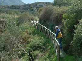
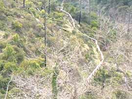
This is just one of many old pathways around this area,
a typical Greek
(short cut) down the lofty slopes to Ano Katelios,
still used by farmers and shepherds today. The trail is
well signposted and follows along the side of the
stream from the village of Pastra and the old wash
houses to the beach of Ayia Varvara (Barbara) to the
left of the village of Kato Katelios. The trail starts
behind the washhouses under the bridge then follows
the stream that once was a fast flowing river which
during Roman times powered 18 waterwheels along its
banks. The ruins of these you will be able to see
quite clearly on route including the old church of
Ayii Anayiri. This updated pathway has a few wooden
bridges and safety rails along the way making the
pathway less precarious and the course easier, foot holes
have been made in part of the terracing to aid you.
However, care must be taken in wet weather, in which
case slight detours through the olive groves in one or
two areas are advisable. The
route has a mixture of tracks, footpaths and road
sections and can be shortened or extended to suit. Parts of the
pathways are slippery after rain.
|
|
|
|
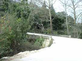
A:
Ask to be dropped of in the village of Pastra by
taxi next to the church of Panayia Gravaliotis.
For the easier down hill route. Opposite the church, the road just off the main
tarmac road
leads you down a short way to the bridge. This bridge
and the continuing road is one of the original roads
on the island built in the mid 1800's by the British.
This road branches off and continues to descend
passing through Alimata to Skala (today's Old Skala)
whose houses were destroyed in the 1953 earthquakes,
still heaped in ruins today, no building survived
except for the belfry of the once large church.
|
|
|
|
|
|
B:
The
wash houses have now received a face life with freshly
painted walls and fencing around the perimeter, this
was used as the washing area by the locals. The ladies
of the village would make their way here to do their
washing, gossip and collect water from the spring,
which still runs constantly today and fills the gully
at the side of the road, even now irrigating the
surrounding land.
|
|
|
|
|
|
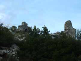
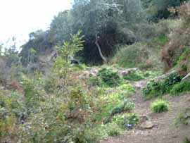
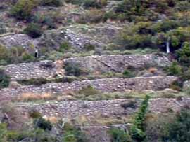
C:
There
is a large area behind the wash house which is a maze
of pathways for you to explore before you make your
descent downhill on the trail towards Katelios. On the
hill above you once stood the ancient city of Pronnoi. This
once powerful citadel was very difficult to capture,
as the view out to sea would prepare its inhabitants to
rally their forces in preparation of any advancing
forces. The city's fortifications were huge walls
made of blocks of stone known as Cyclopean and
difficult to scale. Nearby archaeological evidence
even shows this could once have been the elusive city of
Odysseus.
|
|
|
|
|
|
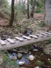
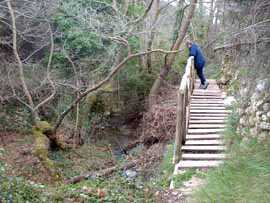
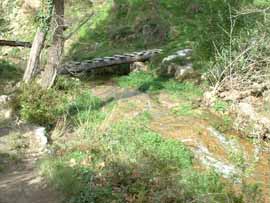
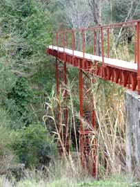
D:
This
is one of a few wooden bridges made to update this
trail, the original footpath took a different course
just as the water does today. The direction of its
flow and power has moved and shifted over the years due to the
many earthquakes the island has suffered over the
centuries.
|
|
|
|
|
|
E:
To
your right is the first and more modern of the water
mills you will be seeing on this walk today, its roof
and walls well covered in ivy. Take care if looking
inside and do not be frightened by but, be aware of
anything moving quickly on the ground or in the
bushes, it is most likely to be just a small green
lizard, but there are snakes on the island so do not
go poking around in holes etc. It is more likely that
you would frighten them away before they could be seen
by you, but if one was asleep in his nice warm bed he
might take offence at being disturbed. A little
further on and you come to the first serious bridge to be
crossed.
|
|
|
|
|
|
F:
The
next mill on your right is markedly much older than
the first and shows you the disastrous signs of
the devastation and destruction of an
earthquake.
|
|
|
|
|
|
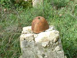
Note:
When we were here there was an old World War 2
helmet found and placed on the pillar - I am sure it
will have probably disappeared before the season
begins. However it should go without saying - please leave
any item such as this and do not remove it as
memorabilia. Thank you.
|
|
|
|
|
|
G:
From this point you can clearly see
how the water was taken from the then fast flowing
river and channelled into
the old concrete water channel . This was then taken off in other directions to
irrigate the land during the summer months.
|
|
|
|
|
H:
The
church of Ayii Anayiri was built in honour of three
men who were all doctors and gave their services free
of charge to the poor of the area, the name itself
means "without money".
|
|
|
|
|
|
|
|
|
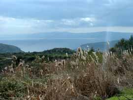
View
of bamboo plumes & Zakynthos
|
Sea
Squill emerging
|
|
|
|
|
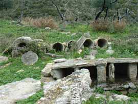
I:
This is the start of the long run of Roman
watermills, (when you reach the lower section you will
be able to turn around and view another above this
one). There were 18 of these amazing water pipes that look just like ' elephant trunks'
which connected together to transport
water down to power the
wheels. What you must remember as you
follow this trail - is that over the
centuries the water course and flow has changed
dramatically. Once the island had bountiful rivers and
streams along with many freshwater springs, however
many of these after the 1953 earthquake ceased to flow
and changed direction, the precious water being diverted through the
disruption underground.
|
 |
|
|
|
This also has happened
over the millennia, but what it does not detract from is
the importance of this whole area in Mycenaean times all the way
through to the Roman era . 3rd century BC Roman
Mosaics have been found in many areas
around here with the Roman Villa in Skala being the
best known about and preserved. It is thought to have perhaps
belonged to the governor of
the region or possibly the island. This then must explain
why this whole area was one of the most powerful on
the island, renowned for its abundant supply of water.
|
|
|
|
|
|
|
|
|
|
J:
This
is a lovely area to sit and enjoy a well earned rest
for a while or even a picnic. Before the climb up the
next slope!
|
|
|
|
|
|
|
|
|
|
|
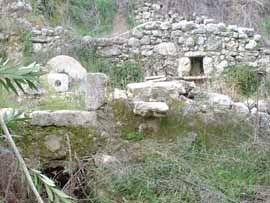
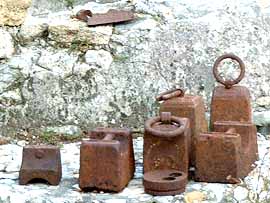
K:
This next section shows three
watermills and the top of the ancient 'hose
pipe' the lower mill has some remains of roof
tiles which have been all fitted together with
concrete caps, used to release the water
when required. This is what remains of the Venetian
era, however the water was still then displaced
to small dams which were then controlled by these ingenious
contraptions. Also we found here weights, an old lantern
and other artifacts. Once again please leave these
where you find them.
|
|
|
|
|
|
|
|
|
|
|
|
L: From
this next mill you will be able to see the old walling
of the terraces behind, even the old steps built in for
ease of access.
|
|
|
|
|
|
M: In
front of you soon you will be able to pick up once
again the old concrete water channel. Then across the
last remaining bridge, made from metal this time,
through the orchards of olive, lemon, orange and walnut
trees to Ano Katelios.
|
|
|
|
|
|
N:
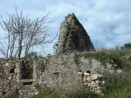
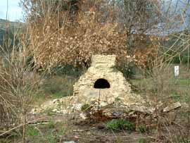
All
that is left within the remains of this old house is
the
traditional beehive shaped oven. The oven
is stuffed with brushwood which is then set alight and
the opening closed with a metal sheet or door. When
the fire has died down it is raked out and the roast
or bread is put inside and left there until cooked.
|
|
|
|
|
|
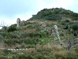
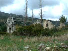
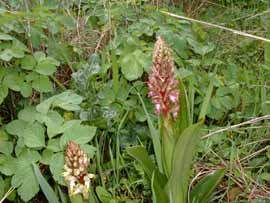
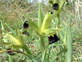
O:
The
final watermill and a little further along what was
once the most resplendent church of Ayios Andreas.
Large and decorative lost forever like most of the
island's history. However I hope today you have seen a
little more of it than you bargained for, but thoroughly
enjoyed yourselves. Below are just a few of the
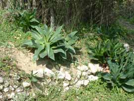
orchids we found in and around the church grounds. |
|
|
|
|
|
|
|
|
|
|
|
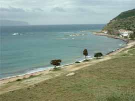
P:
Finally the view of Ayia Varvara beach and Katelios
shoreline on a February day. The beach is being
cleared of its seaweed which washes up onto the
shore and is a problem all over the island in the
winter months. The endeavours of the local authority to clear it all
away is on going,
ready for you to enjoy your stay on the island.
|
|
|
|
|
|

|
|
| |
|
|
|
Walk PK1: Pastra
To Katelios: Distance: 7
Kilometres (4 Miles)
Time:1½
to 2 Hours: Easy
to Moderate:1 steep climb
Click
here for detailed map
1
Make your way behind the wash house and under the road you will find a wooden bridge to cross.
2
Follow the footpath off to the left along the
water course but take care even in the summer it can be
slippery and often trenches are covered with moss and reeds so
beware of any unforeseen holes.
3 Cross over the first of many bridges such as
this with handrails, however as you will notice, these do not
weather the winter very well so please take great care
especially in the rain.
4
After visiting the church take a left until you reach
the next - Roman - watermill then you have a
choice of either walking to your left to the bridge or take
the easier way thought the olive grove.
5
At the end of the crazy paved path take a left.
6
Turn left a little way on following the path through a low
walled path then down the hill side and cross the stream
following the pathway to the next set of railings.
7
Around the bend and you start to descend once more to a
wooden bridge crossing over the stream before making your way
up the other side of the hill. Then down hill on a narrow
pathway follow this evident path until you reach the
metal bridge.
8
After you have crossed the metal bridge make you way behind the bush
to your right over a ditch and sharp left through the orchard
of lemon and orange trees. Making a right onto a dirt
track.
9
Take a right at the houses into Ano Katelios.
10
At this junction the choice is yours, left leads you
down to the beach of Ayia Varvara. or right into the
village of Ano Katelios.
11
First left takes you down to Ayios Andreas then back onto the
main road which leads into Katelios.
|
|
|
